


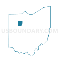
Voting District FOSTORIA SOUTH, Hancock County, Ohio
About
Outline

Summary
| Unique Area Identifier | 647782 |
| Name | Voting District FOSTORIA SOUTH |
| County | Hancock County |
| State | Ohio |
| Area (square miles) | 1.61 |
| Land Area (square miles) | 1.47 |
| Water Area (square miles) | 0.14 |
| % of Land Area | 91.11 |
| % of Water Area | 8.89 |
| Latitude of the Internal Point | 41.14759930 |
| Longtitude of the Internal Point | -83.43296800 |
Maps


Graphs
Select a template below for downloading or customizing gragh for Voting District FOSTORIA SOUTH, Hancock County, Ohio


Neighbors
Neighoring Voting District (by Name) Neighboring Voting District on the Map
- Voting District FOSTORIA NORTH, Hancock County, OH
- PRECINCT FOSTORIA 3-B, Seneca County, OH
- PRECINCT FOSTORIA 4-A, Seneca County, OH
- Voting District WASHINGTON, Hancock County, OH
Top 10 Neighboring County Subdivision (by Population) Neighboring County Subdivision on the Map
Top 10 Neighboring Place (by Population) Neighboring Place on the Map
Top 10 Neighboring Unified School District (by Population) Neighboring Unified School District on the Map
Top 10 Neighboring State Legislative District Lower Chamber (by Population) Neighboring State Legislative District Lower Chamber on the Map
Top 10 Neighboring State Legislative District Upper Chamber (by Population) Neighboring State Legislative District Upper Chamber on the Map
Top 10 Neighboring 111th Congressional District (by Population) Neighboring 111th Congressional District on the Map
Top 10 Neighboring Census Tract (by Population) Neighboring Census Tract on the Map
- Census Tract 1, Hancock County, OH (4,208)
- Census Tract 9629, Seneca County, OH (4,107)
- Census Tract 9630, Seneca County, OH (3,413)